

View from the Summit of Mt. Pinter
Rating: 4.5 out of 5 stars
Recommended supplies and information:
- Leave early in the morning
- Bring at least 100 ounces (3 liters) of water
- Wear a hat that covers neck area
- Small First Aid Kit
- Trekking Pole for the ascent and descent
Approximate Trekking information:
Distance: 5.24 miles (8.4 km)
Total Hiking Time: 4 hours
Elevation at base 1,493 ft to 2,080 ft at summit (Mt. Pinter): 587 ft ascension climb
Metrics: 455 meters to 634 meters at summit (Mt. Pinter): 179 meters ascension climb
Temperature for October 25, 2014: 74.7F to 95.7F / 27.3C to 35.3C
Park Pass Required

Park Pass Map
Tonto National Forest requires a $6 daily park pass that can be purchased at a 24 hour Chevron Gas Station a few miles outside of Saguaro Lake area.

Overview of Trekking Region
Butcher Jones Trail / Off-Trail to Mt. Pinter Loop
Located at Saguaro Lake in Tonto National Forest, Butcher Jones Trail is a delightful trek for all ages and levels of hiking. The basic trail begins at the beach of Saguaro Lake then smoothly guides you through environmental information regarding the history and local fauna of the area.

Beginning of Trailhead, Butcher Jones Trail / Mt. Pinter

Environmental Information, Butcher Jones Trail / Mt. Pinter Loop, Saguaro Lake
Signs are posted in various areas and the trail stems off to a few separate viewing locations. Saguaro Lake is a populated area nearing the initial parking lot. However, the further you trek into the trail the fewer sightseers you will meet. On Saturday, Oct 25, 2014 I stumbled across only two people at the two-mile point of the trail. Although I began my hike at 6:45 am, it wasn’t until about 9:30 am before I saw them. (I trekked off-trail then picked up the main trail later).
Basic Trail
Butcher Jones Trail is approximately 2.5 miles (4 km) in length that splits off into two directions. The trail itself starts out fairly smooth then becomes more uneven and rocky, but later on, it smoothes out again. In one direction it leads you to Burro Cove, a very narrow trail that is rarely trekked. In the other direction, a more popular split brings you to a scenic shoreline access overlook point. Either way both short .25 mile (.4 km) trails allow the trekker to appreciate the desert environment with lush green desert trees and bushes.

Beginning Trail, Butcher Jones Trail / Mt. Pinter

Rougher Trail, Butcher Jones Trail / Mt. Pinter
Mainly, willow, ash, cottonwood, sycamore, and mighty saguaro cactus blazon the path along the way. I have hiked these trails a number of times, and along the main trail beware of Arizona Western Diamondback Rattlesnakes. Now and then they will be spotted curled up lying in the middle of the hiking path. These diamondback snakes blend in very well with the rocks and tan sand. Diamondback snakes have a venomous bite and are extremely dangerous to young children. The greenish Mojave Diamondback is lethal to both children and adults. If stepped on, the snake may bite, and if bitten, seek medical attention immediately.
The start of the basic main trail from the beach levels out at 1,493 feet (455 meters), continues up to 1,646 feet (502 meters) at its highest point, and then descends to 1,607 feet (490 meters) at the end. In the summer months, the second half of the trail is exposed to direct sunlight. I suggest leaving early in the morning and trekking out before temperatures reach above 98 degrees Fahrenheit (37 Celsius).

View along the Main Trail, Butcher Jones Trail / Mt. Pinter

Split Trail, Overnight Fisherman, Butcher Jones Trail / Mt. Pinter
Some areas at the beginning of the trail have litter due to the heavy populated family picnics and careless fishermen. Round trip is about 5 miles (8 km), so allow about three hours to complete the trek.
Off-Trail Mt. Pinter Loop
Considerations
Hiking Butcher Jones main trail a number of times, I felt the urge to go off the beaten path and to explore and GPS the undocumented areas of the Saguaro Lake region. Although I have trekked alone, I would recommend taking a fellow hiker with you. Going “off-trail” can be very dangerous and unpredictable. Only experienced hikers should attempt this alternate trek.
Recommended Gear to take along
- Rugged hiking boots (above the ankle style)
- Trekking pole
- Medical kit
- Cell phone (signals are available in some areas)
- Hat
- Protective glasses
Recommended Gear to always have in your Backpack
- 100 feet (30 meters) of military grade paracord
- Cover (small light tarp or protective rain cover)
- A Knife or Multi-tool with tweezers
- A container for boiling water
- Fire starter or Combustions material (matches, lighter, etc)

Off-Trail Map of Mt. Pinter Ascent, Butcher Jones Trail, Saguaro Lake
The attached map indicates where the off-trail split occurs. However, since there is no trail to follow, natural contours of the terrain can guide you to the top of Mt. Pinter. My suggestion is to climb the mountain from the west side since 90% of the ascent will be in the shade from the morning sun. At the base of the main trail the altitude is 1,506 feet (459 meters). The ascent to the summit is 2,021 feet (616 meters), a 515-foot (156 meter) gain.
This portion of the trek is amazing. A very green desert terrain accented by large rock formations with beautiful views of the lake make this part of the hike very enjoyable. Amazing photographs can be taken from this area. Deep ravines and cave-like structures are within the massive rock walls.

Off-Trail View of Mt. Pinter Ascent, Butcher Jones Trail, Saguaro Lake
About halfway up on the western side of the climb, a huge cave can be seen facing the lake below. It appears, from the charred walls of the cave, people have occupied this location in the past, perhaps Native Americans, and have used it for shelter during heavy rain downpours or a temporary place of travel. A peculiar heavy gauge cable is mounted to the top of the cave and extends downward, tied securely to the ground. Not sure what that cable was used for. Also, I have not yet ventured deep into the cave since I don’t carry a powerful flashlight in my pack.

Cave View halfway up Mt. Pinter, Butcher Jones Trail, Saguaro Lake
Another consideration is possible rattlesnakes or peccaries (javelina, a pig-like mammal) maybe occupying the deep cavern. Both can be aggressive if agitated or surprised.
Moving along a ridgeline, the natural terrain becomes steeper and it forces you to approach the final ascent of the peak from the southwest side of the mountain. Be mindful of the cholla cactus that is prevalent on this side of the peak. Views from the south side of the mountain are spectacular. Saguaro Lake actually wraps around Mt. Pinter along the base. The final ascent is moderately steep and there is very loose rock footing due the dry sun baking ground. A hiking pole helped immensely in this portion of the climb.
Standing on the peak of Mt. Pinter, incredible views from every direction can be seen. Be careful of the 100-foot (30 meter) drop-offs surrounding three sides of the peak. A slight easterly breeze blankets the rocky summit and makes for a quiet and peaceful place to take in the sights and to have a well-deserved brunch.
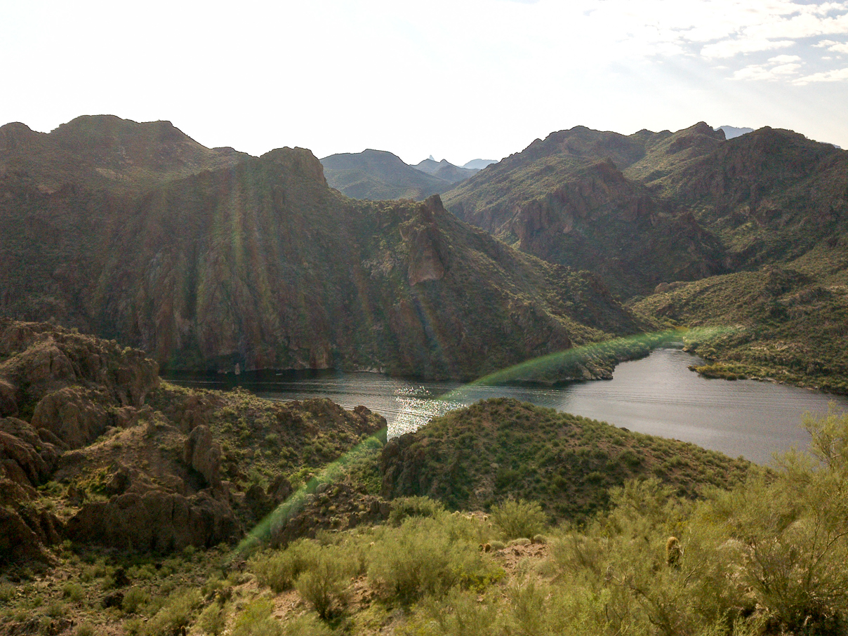
Summit of Mt. Pinter, Butcher Jones Trail, Saguaro Lake

Summit of Mt. Pinter, Butcher Jones Trail, Saguaro Lake
Danger
Leaving the summit, head back down the way you came or traverse over to the eastern side of the mountain. The eastern side is the trickiest part of the descent since there is no trail and the footing is extremely loose. Take great care in heading down this side of the mountain. Once the terrain begins to level out, grassy knolls can be seen sweeping the northern side of the terrain. Much exploration can be done in this area, especially if heading down to the eastern lake region.

Steep Incline Descending Mt. Pinter Eastern Side, Butcher Jones Trail, Saguaro Lake

Grassy Meadow on Northern Side of Mt. Pinter, Butcher Jones Trail / Mt. Pinter Loop, Saguaro Lake
At this point, start trekking across one shallow ravine and head back toward the main trail.
Burro Cove

To Burro Cove, Butcher Jones Trail / Mt. Pinter Loop, Saguaro Lake

Burro Cove, Butcher Jones Trail / Mt. Pinter Loop, Saguaro Lake
The main trail leads you down into the Burro Cove area. This area is densely vegetated and the trail becomes narrow at certain locations. Once at the cove, you will be back down at lake elevation. Burro Cove is mainly visited and approached by water from fisherman with their boats. On several occasions I’ve seen camps setup at the Burro Cove location and it is a favorite spot for some weekend boaters.
Trail Ends, Off-Trail Begins Again

Riparian Region, Butcher Jones Trail / Mt. Pinter Loop, Saguaro Lake
Continuing on the trek, the main trail stops, but animal trails allow you to meander through the riparian area while staying in shade close to the lake. Although the sporadic paths are shaded, be sure to watch for snakes coiled up sleeping. I’ve seen a few, but just watch your step through this area.
Peccary (Javelina)
About a quarter mile (.4 km) in and coming up out of the shaded thicket, I began heading up to the access point towards Pinter’s Point. Suddenly, a herd of javelina darted out from within a shaded bushy area and begin running away in the opposite direction. From what I could see, there were about seven of them varying in size. Some were very small while a couple of them were very large and hefty in stature.

Javelina Area, Butcher Jones Trail / Mt. Pinter Loop, Saguaro Lake

Javelina Area, Butcher Jones Trail / Mt. Pinter Loop, Saguaro Lake

Javelina Sightings, Butcher Jones Trail / Mt. Pinter Loop, Saguaro Lake
I apparently startled them from about 30 yards (30 meters) away. At this point, I began heading straight upward. Pinter’s Point maybe one of the best views of Saguaro Lake. The altitude is only 1,765 feet (538 meters), but the view is remarkable by the surrounding mountains and yellow and green facing algae colored cliffs. Again, a smooth cool breeze comes from the east and is another great spot for a short rest.
Finishing the Loop Off-Trail
After spending a short while on Pinter’s Point, I began to traverse in a northern fashion to another ridgeline and began descending down into a washed out ravine that I knew would head down to the beginning of the main trail where I started. Going through this area, you will get scratched up sooner or later due to weaving through some dense thorny bushes and branches. I managed to get through this time with only two or three scrapes and scratches.

Narrow Thorny Washout, Butcher Jones Trail / Mt. Pinter Loop, Saguaro Lake

Erosion Washout, Butcher Jones Trail / Mt. Pinter Loop, Saguaro Lake
This final trek to the beginning of the main trail will be fully exposed by the sun. There are a few shaded areas if rest is needed. During the final mile, I encountered two more separate clans of javelina herds that scurried up to the ridgeline. Since I was beneath them in a low-lying ravine area, in fear, they hurried away from my location.

Final 100 Yards to Main Trail, Watch for Diamondback Rattlesnakes, Butcher Jones Trail / Mt. Pinter Loop, Saguaro Lake
The final 100 yards (100 meters) of the dried out ravine, at an altitude just above the elevation of the lake, is a dark thickly moist dense region. Take care in watching for diamondback rattlesnakes. I’ve encountered one a few months ago. The ravine brings you back onto the main trail heading back into the beach area and parking lot.
Summation

A Great Desert Challenge and Adventure, Butcher Jones Trail / Mt. Pinter Loop, Saguaro Lake
Butcher Jones Trail in combination with the Mt. Pinter Loop is one of the best examples of Arizona trekking. If you care to experience various desert terrains, animal wildlife, and an abundance of vast desert plant life, then this is the trail for you. I would highly recommend trekking with a friend and in the summer months starting out on the trailhead as early as possible.
View all images of the trail: http://www.arizonatrekker.com/treks/butcherjones/
View Complete Trekking Data: http://www.movescount.com/moves/move43858876
Directions:
From Phoenix: Head towards Mesa and hop on the N. Beeline Highway Route 87 going North. Pass Ft. McDowell and a few miles further take a right on the N. Bush Highway Exit. The Butcher Jones Entrance will be on the left a few miles down.
Map Directions
Personal Guide Information
For a small fee I will guide a small group through the Mt. Pinter Loop Trail. Please contact me if interested. ArizonaTrekker@gmail.com
